


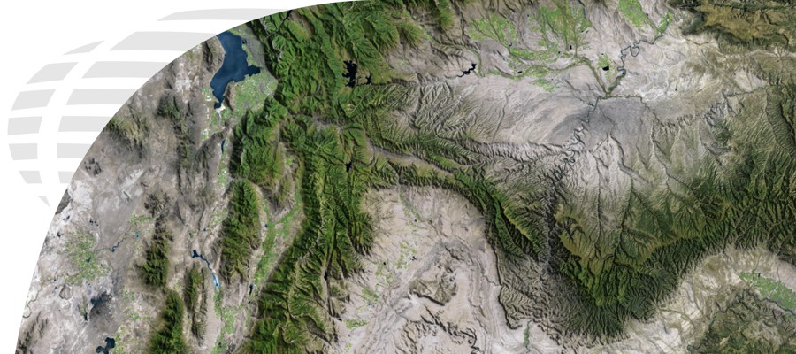


ArcGIS Tracking Analyst
“Reveal and Analyze Time-Based Patterns and Trends in Your Data”
ArcGIS Tracking Analyst extends the time-aware capabilities of the ArcGIS system with advanced functions to let users view, analyze, and understand spatial patterns and trends in the context of time. By providing tools for time-dependent symbolization and time-based analysis, ArcGIS Tracking Analyst automates and enables the tracking and discovery of time-related trends and patterns.
Features of ArcGIS Tracking Analyst:
- Identify Trends Over Time and Make Better Decisions
- Monitor Your Mobile Resources and Display Patterns in Their Movements
- Custom Notification of Important Events and Report on Patterns Related to Time and Space
- Create “Geofences” to Detect when People, Assets, or Vehicles Enter or Exit Restricted Areas
ArcGIS Spatial Analyst
“Derive Answers from Your Data Using Advanced Spatial Analysis”
ArcGIS Spatial Analyst provides a wide range of spatial modeling and analysis tools. These tools provide powerful options for comprehensive, raster-based spatial analysis. With ArcGIS Spatial Analyst, users can employ an extensive range of data formats to combine datasets, interpret new data, and perform complex raster operations such as terrain analysis, surface modeling, and much more. ArcGIS Spatial Analyst software’s strong integration with the ArcGIS Desktop allows users to create and implement evaluation models quickly and easily.
|
Features of ArcGIS Spatial Analyst:
|
Benefits of ArcGIS Spatial Analyst:
|
ArcGIS Publisher
“Freely Share Your Maps and Data with a Wide Range of Users”
ArcGIS Publisher lets users easily share and distribute Geographic Information Systems (GIS) maps, globes, and data with anyone. Using ArcGIS Publisher, you can convert ArcGIS map and ArcGlobe documents to published map files (PMFs) that are viewable with ArcReader, a free application. PMFs contain instructions about the location and symbology of data layers so users can securely share dynamic electronic maps locally, over networks, or via the Internet. ArcGIS Publisher also enables users to easily package PMFs together with their data, if desired.
Features of ArcGIS Publisher:
- Security for Your Maps and Data
- Build Custom Viewers for Your Maps
- Create Visually Stunning Interactive Maps
- Easily Parcel Data and Maps for Distribution
- Effortlessly Provide Interactive Maps and 3D Globes to Your Users
Benefits of ArcGIS Publisher:
- Government Agencies that Need to Distribute Data and Maps to the Public
- Data Providers Wanting to Allocate Preauthored Maps with Their Data
- Distribute Maps within your Business
ArcGIS Schematics
“Represent and Understand Your Networks to Shorten Decision Cycles”
ArcGIS Schematics is a solution for the automation of graphic representations of ArcGIS geodatabases. ArcGIS Schematics allows users to better manage and visualize virtually any linear physical and logical network including social and economic networks. With ArcGIS Schematics, any kind of network, including electric power, traffic lights, delivery routes, and computers, can be represented. Using ArcGIS Schematics, users can quickly check network connectivity, understand network architecture, and shorten the decision cycle by presenting focused views of the network.
Features and Benefits for ArcGIS Schematics:
- Optimize Network Design and Analysis
- Perform Quality Control of Network Data
- Dynamically Interact with GIS Through a Graphic View
- Automatically Generate Schematics from Complex Networks
- Conduct Forecasting and Planning (modeling, simulation, and comparative analysis)
ArcGIS Network Analyst
“Perform Sophisticated Logistical Analysis”
ArcGIS Network Analyst provides network-based spatial analysis for all sorts of logistical purposes. Using ArcGIS Network Analyst, users can dynamically model realistic network conditions, including one-way streets, turn and height restrictions, speed limits, and variable travel speeds based on traffic. Users can easily build networks from Geographic Information Systems (GIS) data by using a sophisticated network data model.
Features and Benefits of ArcGIS Network Analyst:
- Find Shortest Routes
- Locate Closest Facilities
- Create a Network Using your Existing GIS Data
- Define Service Areas Based on Travel Time or Distance
- Calculate Travel Costs from each Origin to all Destinations
- Produce Efficient Routes for Fleet Vehicles Visiting Multiple Locations
- Determine Optimal Facilities Locations by Performing Logistical Analysis
- Use “Time Windows” to Schedule when Vehicles can Arrive at Locations